
Trail Map is published for Lynnfield’s Bow Ridge Conservation Area/Kallenberg Quarry
A trail map brochure is now available for visitors to Lynnfield’s Bow Ridge Conservation Area/Kallenberg Quarry – one of five Conservation areas in town. The brochure provides recreational trail mapping in addition to information about points of interest, historical significance and accessibility. The brochure is available at the Lynnfield Public Library and in the information rack outside of the Planning & Conservation office at Town Hall. It can also be downloaded below.
This trail map brochure was produced by staff GIS expert Patrick McDonald, with significant input from 2022 Eagle Scout Dan West. In February, West’s Eagle Scout proposal was unanimously approved by the Conservation Commission, which included the build and installation of a wetland passage bridge, and the mapping and blazing of the unmarked trails on the property. The bridge remedies a particularly vulnerable portion of the trail which often floods after rainstorms. Blazing the trails with color-coded trail markers helps visitors to better understand and follow trails of interest.
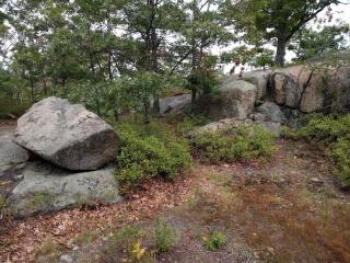
This open space is a treasured Lynnfield conservation area. Bow Ridge marks the highest point in Lynnfield, from which visitors can see the Boston skyline to the south and New Hampshire’s Mount Monadnock to the north. Kallenberg Quarry holds much historical significance, having earlier supplied quarried granite to numerous Boston area and local sites. The area also opens up into Lynn Woods Reservation, a 2,200-acre municipal forest park in Lynn, MA which offers over 30 miles of scenic trails, three active reservoirs and additional formal settings to explore.

| Attachment | Size |
|---|---|
| 865.67 KB |