
Lynnfield Approves New Town Zoning Map
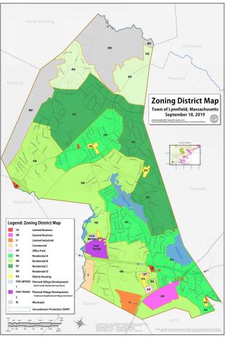
Capping a multi-department effort spanning months of investigatory work and data analysis, Lynnfield formally approved its new September 18, 2019 Lynnfield Zoning Map at the October 21 Town Meeting. The new map supersedes the Town’s 1953 version. The Town Clerk will now submit the map to the State’s Attorney General’s office which will have up to 90 days to approve. Once approval is received, the map will be in effect back to the October 21, 2019 Town Meeting date.
Updating the Map serves multiple objectives: 1) to incorporate all zoning changes and adaptations recorded in all Town Meetings (Annual and Special) from 1953 to present; 2) to update all shapefiles for use in a Geographic Information System (GIS); 3) to bring the Town’s data storage and usage procedures into compliance with the State’s MassGIS standards, and 4) to permit future, in-house data analysis of land and parcels (Open Space, build-out analysis, etc.).
“This was a monumental effort on the part of many of our people at Town Hall,” notes Town Administrator Rob Dolan. “Planning & Conservation spent months investigating records dating back to the time of the original 1928 Zoning Map. Our new employee Patrick McDonald is a GIS and database expert, and was able to apply his skills at an in-house level rather than the Town incurring a significantly higher rate that would have been paid to outside consultants.”
Massachusetts General Laws require all towns to have a valid, up-to-date map showing all zoning districts. Planning Board Chairman Brian Charville is pleased with the results. “We now have a modernized, GIS compliant, detailed map with correct zoning for each parcel.”
The full presentation of the Zoning Map update project made at the October 2 Planning Board meeting is here: https://storymaps.arcgis.com/stories/189b8949c8944b65b5738278c73718f0