
2023 FEMA Maps information
The Federal Emergency Management Agency (FEMA) has notified the Town of Lynnfield that they are preparing to revise the maps used to determine flood insurance rates. Highlights are bulleted below and there are links to important information below. FEMA is posting notices in the Boston Globe on August 21st and August 28th, 2023. There is a 90-day appeal period that begins on August 28th and ends on November 26th, 2023.
- Data used by FEMA in determining any changes to the maps are found in the Flood Insurance Study (FIS) and then included on the Flood Insurance Rate Map (FIRM).
- FEMA has posted digital copies of the revised FIRM and FIS report materials to the following website:
https://hazards.fema.gov/femaportal/prelimdownload/. - FEMA will also publish a separate notice of the flood hazard determinations on the “Flood Hazard Determinations on the Web” portion of the FEMA Website:
https://www.floodmaps.fema.gov/fhm/BFE_Status/bfe_main.asp. - The sole basis for any appeals will be the possession of knowledge or information indicating that the proposed flood hazard determinations are scientifically or technically incorrect.
Any interested party who wishes to appeal should present the data that tend to negate or contradict FEMA’s findings to the Town Engineer, Lisa DeMeo, P.E., by November 13th to provide sufficient time to consolidate all responses and submit one package from the Town.
Below are documents sent to the Board of Selectmen as FEMA’s notice of the map revisions. These documents can also be found at the bottom of this page.
- Letter to Select Board from FEMA
- Federal Register Notice
- Boston Globe Notice
- Scientific Resolution Panel Overview
For additional information about the Preliminary FEMA Map Products,
please visit the FEMA Map Service Center at:
https://hazards.fema.gov/femaportal/prelimdownload/
Select "Massachusetts" and "Essex County"
Then navigate to, and click to expand, the Preliminary Products issued on 02/20/2023 for Essex County, Massachusetts
The portion of the southern Essex County Index Map that covers Lynnfield is shown below:
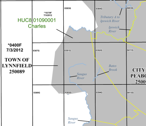
Please use the above numbers to identify the map to download for your section of Lynnfield.
Lynnfield is composed of maps:
| (N Reading) | 25009C0383G | (Middleton) | (Danvers) |
| 25009C0387G | 25009C0389G | 25009C0391G | (Peabody) |
| 25009C0392G | 25009C0393G | 25009C0394G | 25009C0413G |
Please see attached files (below) for more information