
Trail Map is published for Lynnfield’s Partridge Island Conservation Area
A trail map brochure is now available for visitors to Lynnfield’s Partridge Island Conservation Area - one of five Conservation areas in town. This is the second trail map to be published, following the first trail map for Bow Ridge Conservation area/Kallenberg Quarry.
Produced by staff GIS expert Patrick McDonald, the brochure provides recreational trail mapping in addition to information about points of interest, historical significance and accessibility. The brochure is available at the Lynnfield Public Library and in the information rack outside of the Planning & Conservation office at Town Hall. It can also be downloaded below.
Partridge Island is surrounded by Reedy Meadow, the largest freshwater cattail marsh in Massachusetts. Formally known as “Lynnfield Marsh”, in 1972 it was designated a National Natural Landmark by the National Park Service. Measuring 540 acres, Reedy Meadow is home to numerous rare and endangered bird, plant and amphibian species. It is listed as a Rare Wetlands Habitat by the Natural Heritage and Endangered Species Program, and is certified as a Massachusetts Important Bird Area (IBA) by Mass Audubon.
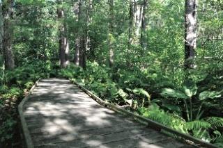
According to the “Municipal History of Essex County in Massachusetts” by Benjamin F. Arrington, 1922, Partridge Island was a long-time site of a Native American camp. Early settlers harvested meadow hay, cranberries and peat. In 1976, the Lynnfield Bicentennial Commission sponsored The Partridge Island Project, creating 3,600 feet of trail and elevated boardwalk from Main Street to Partridge Island. Each year Reedy Meadow attracts many hikers, bird watchers, school groups and others who enjoy its peaceful surroundings, and native plant and animal species.
| Attachment | Size |
|---|---|
| 2.06 MB |